
OS MapFinder App

One of the best ways of exploring a landscape that is either familiar or unfamiliar is to make use of an Ordnance Survey map.  

A new app was launched on the iOS store yesterday which a lot of people are going to find useful.
It's produced by the Ordnance Survey, and called OS MapFinder.

The app comes with a basic high level map of the whole country preloaded, as well as a sample map tile around Exeter - so the folks of Exeter get lucky :)
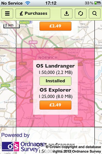
Further tiles can then be downloaded (for either 69p for 1:50 000 or £2.49 for 1:25 000) as an in-app purchase.

Map tiles can be explored, and routes can be added on and plotted. The app will also store routes which have been walked or cycled.
Places can be found using a search by postcode, name or grid reference.

If you want to see more about the app, there's a YouTube video below which shows you a lot more.


Comments

Popular posts from this blog

Explore the world with the Go Jetters

Really useful post and resource for those teaching Primary Geography . A new set of characters called the Go Jetters who teach young people about key geographical ideas. Geography helps children to make sense of their world. Very young children are naturally curious, and they love to actively explore the world around them, noticing all kinds of detail. That’s why they need to develop geographical vocabulary like the names of places, people and things, and the words needed to describe and locate them. It helps to think of children as little geographers – they each have their own world of private geographies  - the places they name for themselves with meanings that only they understand: the dens where they hide out with their friends, special meeting places in the school playground. Whether they’re playing in the back garden, or splashing through a muddy puddle on the way to school, children are intrepid explorers making new (to them) discoveries about the world every sing...

Edward Storey - Fenland chronicler and poet

I have worked in the Fenland city of Ely for the last six years - commuting in all weathers and at all times through the Norfolk and Cambridgeshire Fens... Edward Storey has died at the age of 88. He was a chronicler of the Fens: an author and poet. There was a lovely piece on Edward on BBC Radio Norfolk that I heard yesterday on the way home, which described him as 'a poet of place'. You walk the roof of the world here. Only the clouds are higher And they are not permanent. Trees are too distant for the wind to reach And mountains hide below the horizon. The wind labours through reed As though they were the final barrier. Houses and farms cling like crustations To the black hull of the earth. Here, you must walk with yourself, Or share the spirits of forgotten ages. Keith Skipper has written a lovely piece in the EDP. More to come on Edward in a future blog post.... Image: Alan Parkinson - Fens near Manea - CC licensed

Making Space for Sand

  Making Space for Sand is a project I was made aware of recently. The ‘Building Community Resilience on a Dynamic Coastline by Making Space for Sand’ project (also known as Making Space for Sand or MS4S) is one of 25 national projects funded by DEFRA as part of the £200 million Flood and Coastal Innovation Programme (FCRIP).  The programme will drive innovation in flood and coastal resilience and adaptation to a changing climate. The project website has an excellent section outlining the formation of Sand Dunes, particularly within the located context of Cornwall. Sand Dunes are an important part of the coastal defences in the locations where they are found. I am particularly familiar with the dunes on the North Norfolk Coast at places like Holkham.  I've previously carried out fieldwork on those dunes with both GCSE and 'A' level students, and also  Atkins has provided GIS support and created some visualisations of future landscapes.